Walks near Grange-over-Sands - Allithwaite, How Barrow and Cartmel (circular, 6.5 miles)

This fairly easy-going, picturesque walk through the Cartmel Peninsula takes in stunning views of Ulverston and the River Leven (shown above), as well as a panoramic Lake District vista that includes all of the area's southern-most mountains, as well as most of county's highest peaks.
Being circular, this walk can start and finish from any point on the route, but as roadside parking is easy to find in Allithwaite (a small village next to Grange-over-Sands), this write-up begins at the north-west edge of the village where Locker Lane meets Templands Lane at a curved junction of Boarbank Lane.
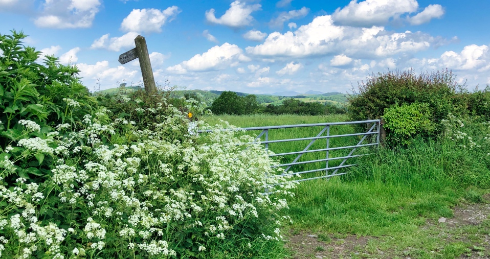
Walk north out of the village on Templands Lane, past a few nice houses, one of which features a superb Wisteria with embedded red roses. A short distance further and you will see this gate (above) on your left, which has a squeeze-stile to the left of the footpath sign. Go through the gap and head west.
Follow the footpath alongside a hedgerow on your left, through a gate which is usually wide open, then walk diagonally-right to the far-right corner of the field, which is hidden below high-ground until you are almost on top of it.
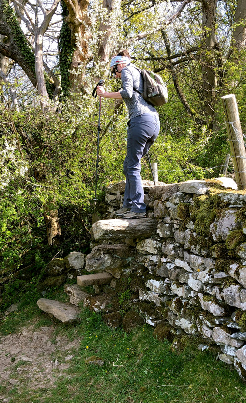
In typical Lake District fashion, the footpath features a stone-stile over a wall with a steep drop on the other side (shown right). The stone steps are large, but the high wall and steep drop on the other side make for a descent that elderly or infirm walkers might struggle to negotiate.
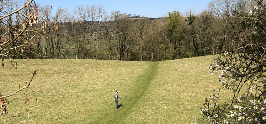
Once over the wall, head slight-right to the dip in the field shown in the image below (taken in winter), and on through the squeeze-stile next to the gate in the far-right corner of the field. Whilst the path might look obvious in this photo, things might look different in the summer, but a path of sorts should normally be visible through the grass. If you walk this route in the spring, you will be able to find your way with your eyes closed, for on the other side of the squeeze-stile is a short path that is surrounded by wild garlic which assaults one's senses!
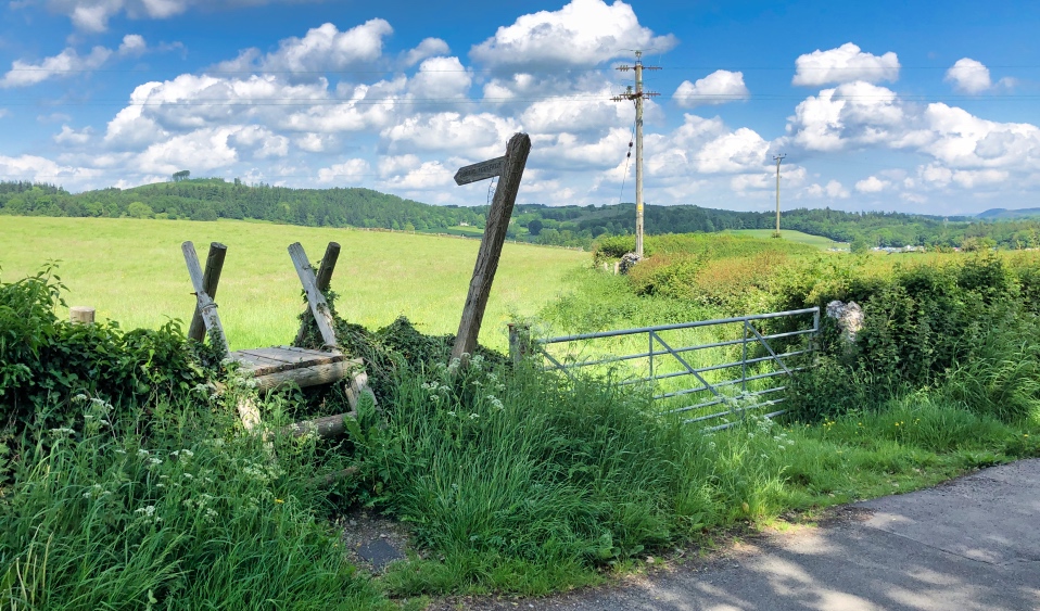
Walk ahead along the shaded path, then left alongside a high garden fence, then right alongside a newly converted stone barn, then through a small courtyard (yes, you are on a public footpath) and onto the Birkby Hall driveway on your right. Follow this to the Cartmel Road and look right where you will see a step-stile waiting patiently for you to give its lonely existence some purpose (shown below). Know that as you climb over this rather solid of structures, in its heart it thanks you for using it, even if it can't tell you as much.
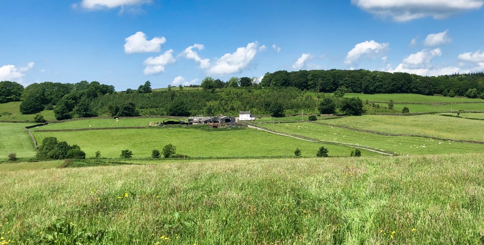
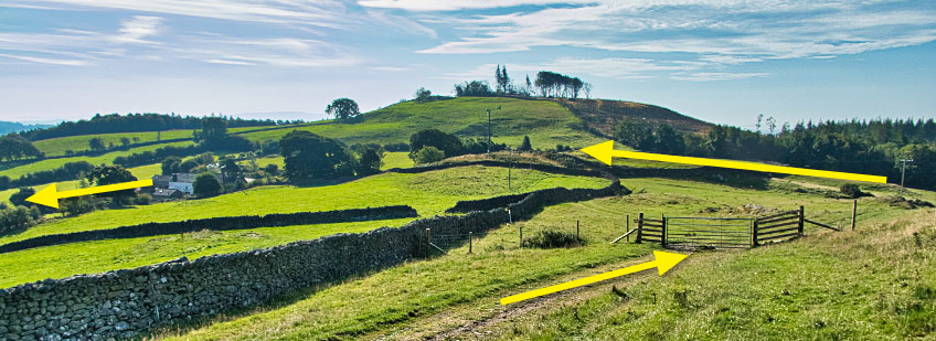
As you follow the footpath down the side of the field in front of you, you will eventually come to a wide gap in the end-wall, from where you will be able to see the next few stages of your walk (see image below). What is not shown in the photo below, is the view across Morecambe Bay to your left, or the view of the distant Lake District mountains to your right. In this blog-article you can see some photos taken in the summer, and some in the winter. It matters not when you complete this walk though, for as long as it is not foggy or misty, the views all along range between beautiful and stunning.
Once through the gap in the wall (where the photo below was taken from), turn immediate right and follow the perimeter of the field along and then down to the far-right corner where you exit through yet another squeeze-stile onto the main Holker-to-Cartmel Road. Almost opposite you now is the entrance road to Low Bank Side Farm, which you should take (see the diagonal road in the photo below) across the River Eea.
Walk to and through the farmyard, upwards and through a noisy double-gate with a heavy metal latch (hold the larger gate carefully whilst opening the smaller one). Opposite you now, over to the left, is a tall wooden gate on a bank that you should go through. This leads steeply upwards through dense shrub-land to a stone-stile and gate at the very top of the land behind the farm in the photo below. In early summer, the path can be a little overgrown, but there are no stinging nettles worth mentioning, and if in doubt when the path spits, just keep following the dominant pathway uphill.
Once through the gate at the top of the shrub-land, follow the path upwards past the woods on your right, then downwards to a squeeze-stile hidden behind a tree in the far left corner of the wall ahead, then walk down to what we call 'Pine Point' for what should be obvious reasons.
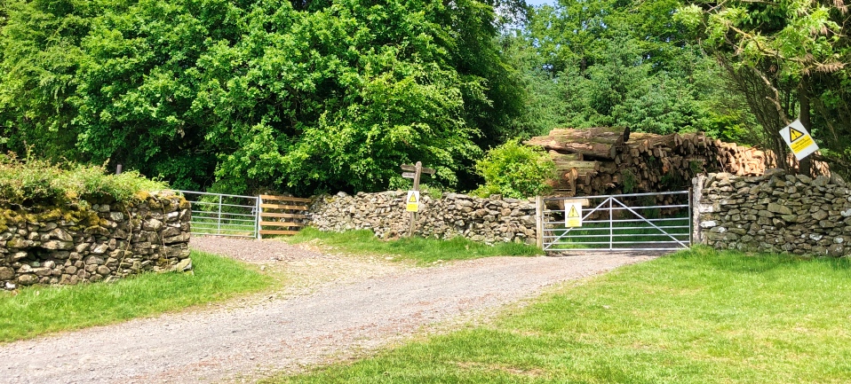
Walk over this large junction of tracks and paths, and through the gate to your right that leads onto a very long, straight lane running uphill alongside Long Scar. At the very top of this lane, go through the gate round the corner on your left (shown below), NOT the gate leading directly ahead of the lane, which is clearly marked as being an active logging area, but a public footpath nonetheless.
Follow the lane westwards, which then bends gently north as it leads to a gate which you should go through (or climb over if you don't fancy tugging the particularly stiff spring-latch). You will now see How Barrow in front of you, looking - if you are in the right place - not at all unlike the picture shown below.
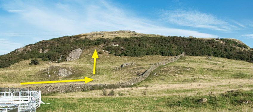
Walk round the sheep pens on your left (or imagine where they might normally be, depending on the time of year), through the gates on your left in order to position yourself at the foot of the climb shown above i.e. on the other side of the long stone wall. This climb is not shown on the OS map as a footpath, and whereas I would not normally encourage anyone to walk on private land that isn't a footpath or bridleway, How Barrow is one of those landmarks where the landowner does not seem to have a problem with people walking to see the views (we were told this by one of the landowner's representatives).
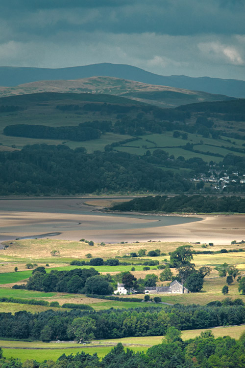
The big town to the west, across the far side of Cartmel Sands is Ulverston. The structure that looks like a lighthouse high up on Hoad Hill to the north-east of the town, is not actually what it seems. It was built in 1850 as a 100ft scale replica of an early Eddystone Lighthouse (designed by John Smeaton), erected to commemorate Sir John Barrow, a founder member of the Royal Geographic Society, who was born in Ulverston.
The photo of the Greenodd Sands shown here to the right was taken from the top of How Barrow, looking north-west towards the dramatic skyline of the Lake District mountains.
When you have had your fill of magnificent views and gloriously fresh air, head over and down the hill in a northerly direction, through a gate in a long wall, and turn right. After a short distance you will come to another gate shown below.
Go through this gate and follow the path down and round to the left, through another gate, past a relatively-small wind turbine and along the outer wall of a rental cottage, onto an access road that in turn leads onto a slightly wider road that heads east (right) towards Cartmel. This is not a busy road by any means. In fact, of all the many times we have walked it, I could count on one hand the number of times we have met a vehicle. Follow this road downhill, past Barns Bank Plantation on your left, to Walton Hall Farm on your right (shown below as you walk down the lane towards its entrance).
The entrance to the farm does not display a public footpath sign (that we have ever noticed), but be assured that it does have a footpath running through the main entrance, round and past the front of the farmhouse on your right, and then on to a gate in the far-left corner of the large farm yard that you now find yourself standing in. The photo below shows the gate that you need to exit the farm through, and note that on your way out, you will see a very faded footpath way-marker on the gate post.
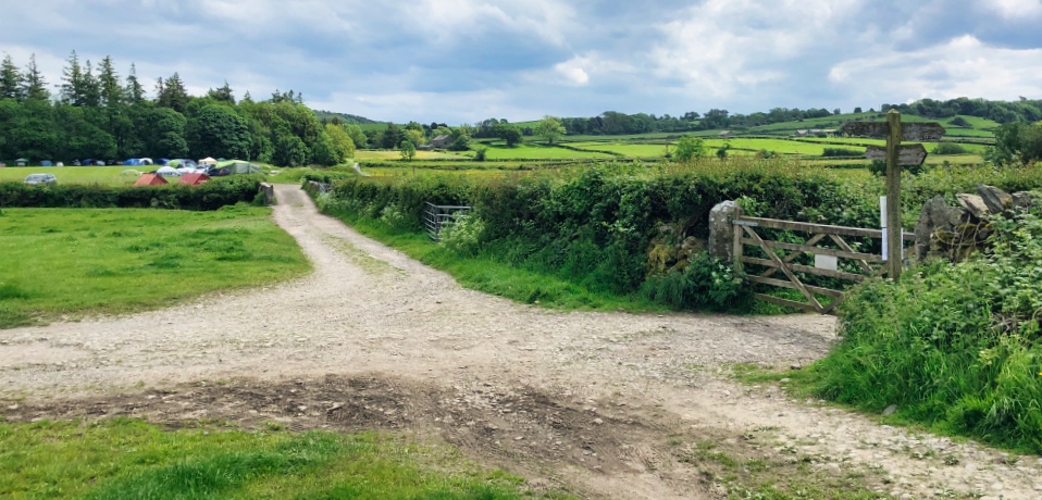
Follow the lane a short distance to a river/ford/dry-bed (depending on the time of year), over the concrete foot-bridge and up and round the track in an easterly direction. Ahead of you now will be the junction of tracks shown below. If there is no event on at Cartmel Racecourse i.e. if it is not a Bank Holiday weekend, you can turn left and head into Cartmel via the racecourse if you wish. Or if you can smell horses, or hear the racecourse tannoy system, or if the field in front of you is full of cars, tents and slightly inebriated racegoers, keep walking straight ahead towards the camp-site shown below, over the river, and follow the track just slightly to the right of the camping field's perimeter. Obviously if there is no racing on when you do this walk, the camping field will look not at all unlike an empty field. But if the racing is in full-swing, expect to see lots of very posh SUVs next to huge tents with suits and dresses hanging up outside.
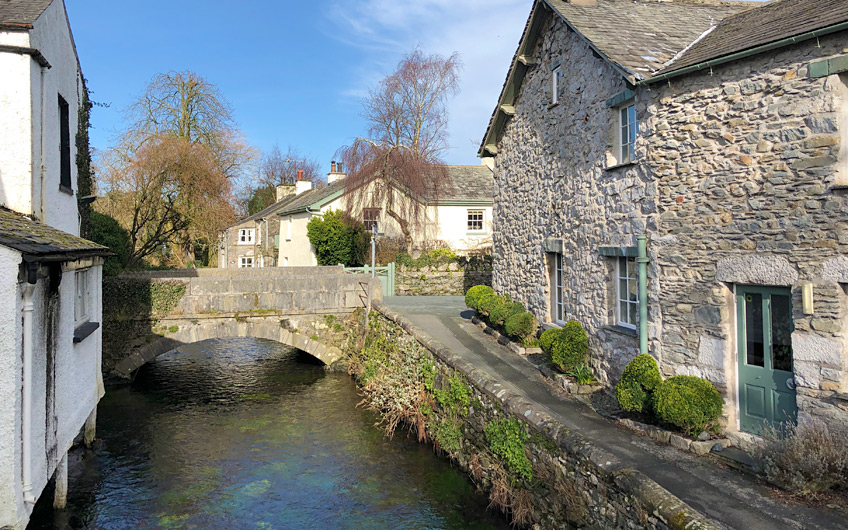
The lane emerges onto the main Cark-to-Cartmel road, which is not normally busy except on race weekends. Turn left and follow the road into Cartmel, turning left again at Headland Cross (closed to traffic on race weekends). This road leads into the village proper where you can enjoy a refreshing beer and a packet of crisps ...or a cup of tea and lunch; whatever you fancy, but be aware that the prices in Cartmel reflect the village's popularity with tourists. If locally-brewed beer or lager takes your fancy, I can wholeheartedly recommend The Royal Oak, which is immediately to your left as you cross the River Eea into the village square. Cartmel is the quintessential English village so have your camera ready to take those 'chocolate box' pictures.
Obviously if you'd rather not visit Cartmel, you can turn right at Headland Cross and head straight back to Allithwaite, saving yourself about half-a-mile off your walk, but even on busy race days, Cartmel is such a lovely place to stop for refreshments that it would be a shame to miss it.
Once you have torn yourself away from the sleepy village setting (or bustling tourist-trap, depending upon the time of year), head back out of the village the same way that you came in, back to the Headland Cross road junction (marked by a stone cross, funnily enough). Cross the Cark road and follow the road-with-no-name opposite, up a gentle rise and on into Allithwaite. When the road bends to the left by The Pastures holiday lodge park, keep walking straight ahead up the narrower Templands Lane, which eventually leads to the junction with Locker Lane, from where you started your walk some six-and-a-half miles ago.
If you complete this walk, please let me know what you think of it in the comments section below, as it would be nice to know if my efforts are found to be worthwhile.

")