Walks near Grange-over-Sands - two trigs and a packet of crisps (circular, 9 miles)

Being circular, this wonderfully picturesque walk can start and finish from any point on the route, but as roadside parking is fairly easy to find in Allithwaite (a small village immediately next to Grange-over-Sands), this write-up begins at the top of the town where the Cartmel Road intersects with Wart Barrow Lane, just past the village primary school.
Walk north out of the town on the Carmel Road but just before you pass the last house on your left, take Template Gate lane alongside it, marked with a wooden footpath sign. Follow it to the end and turn right onto the road that leads into Cartmel from Locker Lane - the road which the author has never been able to find a name or number for!
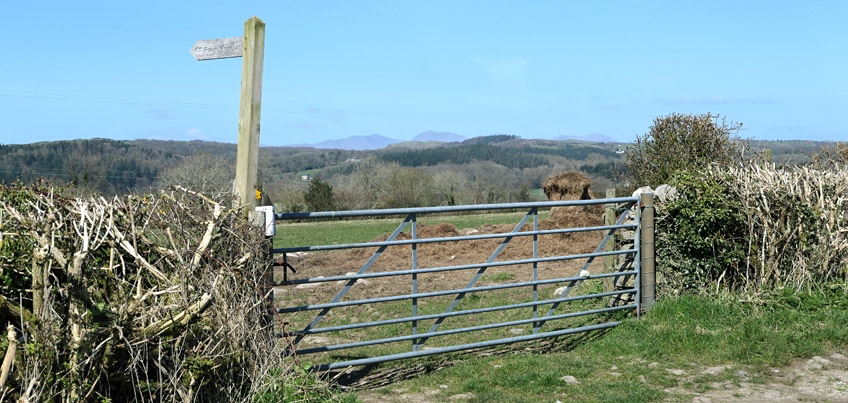
A short distance up the road you will see this gate (above) on your left, which has a squeeze-stile to the left of the footpath sign. Go through the gap and head west.
Follow the footpath alongside a hedgerow and through a gate, then walk diagonally-right to the far-right corner of the field, which is hidden below high-ground until you are almost on top of it.
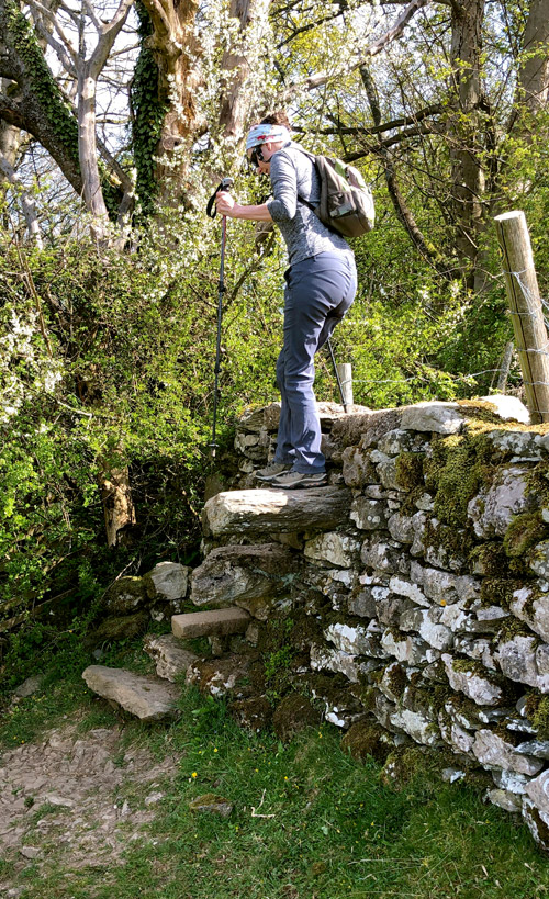
In typical Lake District fashion, the footpath uses a stone-stile over a wall with a steep drop on the other side (shown right). The stone steps are large, but the high wall and steep drop on the other side make for a descent that elderly or infirm walkers might find a little disconcerting.
Once over the wall, head slight-right to the dip in the field shown in the image below, and on through the squeeze-stile next to the gate in the far-right corner of the field.
Walk along the shaded path, then left alongside a high fence, then right alongside a low barn, then through a courtyard and onto the Birkby Hall driveway on your right. Follow this to the Cartmel Road and look right where you will see a step-stile waiting patiently for you to give its lonely existence some purpose. Know that as you climb over this rather solid of structures, in its heart it thanks you for using it, even if it can't tell you as much.
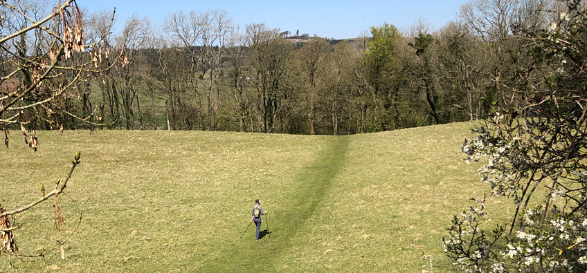
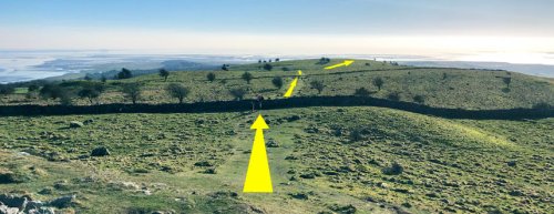
As you follow the footpath down the field, you will eventually come to a wide gap in the end-wall, from where you will be able to see the next few stages of your walk (see image below). What is not shown below, is the view across Morecambe Bay to your left, or the view of the Lake District mountains to your right. In this article you will see some photos taken in the summer, and some in the winter. It matters not when you do this walk for as long as it is not foggy or raining, the views all along range between beautiful and stunning.
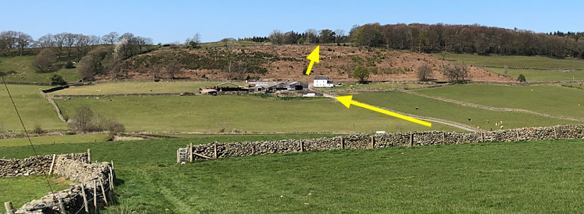
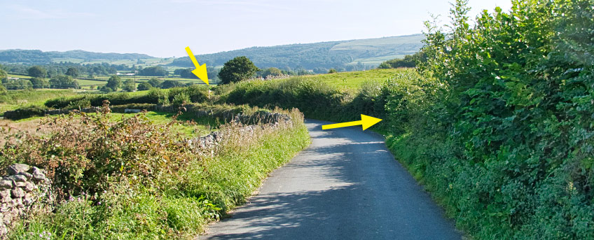
Once through the gap in the wall, turn immediate right and follow the perimeter of the field down to the far-right corner where you exit through yet another squeeze-stile onto the Holker-to-Cartmel Road. Almost opposite you now should be the entrance road to Low Bank Side Farm, which you should take (see the long yellow arrow below) across the River Eea. Walk to and through the farmyard, upwards and through a noisy gate with a heavy metal latch. Opposite you now, over to the left, is a wooden gate that you should go through, which leads upwards through dense shrub-land to a stone-stile and gate (see the highest yellow arrow below).
Once through the gate, follow the well-trodden path past the woods on your right to a squeeze-stile hidden behind a tree in the far left corner of the walls ahead, then down to what we call 'Pine Point' for what should be obvious reasons.
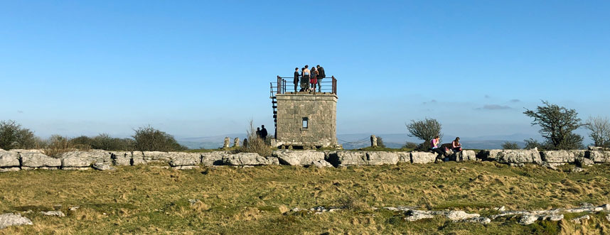
Walk over the junction of roads and paths, and through the gate to your right that leads onto a long, straight lane running uphill alongside Long Scar. At the very top of this lane, take the gate on your left, NOT the gate leading directly ahead of the lane. Follow the lane westwards, which then bends gently north as it leads up to a gate which you should go through. You will now see How Barrow in front of you, looking - if you are in the correct location - not at all unlike the picture shown below.
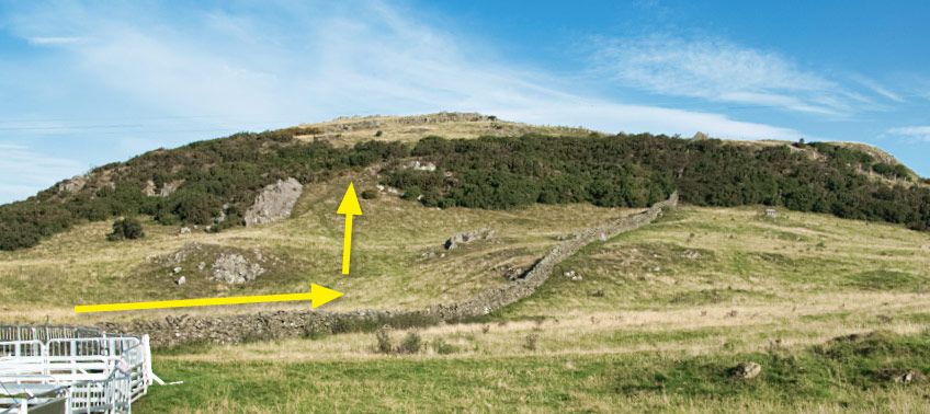
Walk round the sheep pens on your left, and through or over the various gates in order to position yourself at the foot of the climb shown above. This climb is not shown on the OS map as a footpath, and whereas I would not normally encourage anyone to walk on non-open land that isn't a footpath or bridleway, in this instance, as with Fell End which you will climb near the end of this walk, How Barrow is one of those landmarks where the landowner does not seem to have a problem with people walking to see the views.
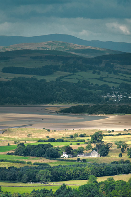
The photo of the Greenodd Sands shown here to the right was taken from the top of How Barrow, looking north-west towards the Lake District mountains.
When you have had your fill of fine views and fresh air, head back down the hill in a northerly direction, through a gate and turn right. After a short distance you will come to another gate shown below.
Go through this gate and follow the path down and round to the left, through another gate, past a small wind turbine and a rental cottage, and onto a side-road that in turn leads onto a slightly wider road that heads east (right) towards Cartmel. This is not a busy road. In fact, of all the times we have walked it, I could count on one hand the number of times we have met a vehicle on it. Follow this road downhill, past Barns Bank Plantation on your left, and Walton Hall Farm on your right, until you eventually see a view like this...
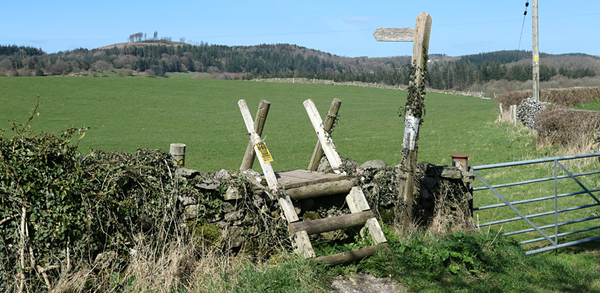
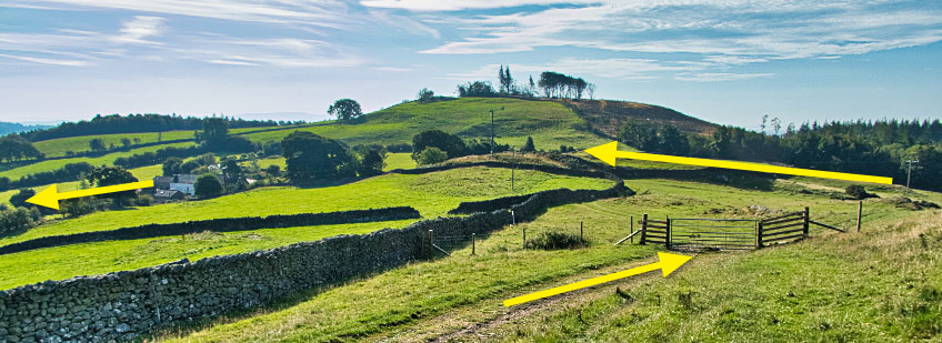
Take the first footpath squeeze-stile that you see (right yellow arrow above), or the second (left yellow arrow above) if you miss the first one. Walk uphill and into Park Wood, which is a delightful wooded area and vast natural stumpery offering fern-strewn cool shelter from the sun on hot days.
Follow the woodland path downhill until you see a small gate to the racecourse in front of you. When I say "gate to the racecourse", I mean that as you go through it, you will find yourself on the main race track between two jump fences, so don't plan to take this route if the races have an event on the day you go, as obviously you might not be allowed through.
Assuming that you are clear to continue, walk across the race track, past the cricket pitch on your left, and over to the main car park, from where you can exit the race course and walk into Cartmel for a refreshing beer and a packet of crisps ...or a cup of tea and lunch; whatever you fancy, but be aware that the prices in Cartmel reflect the village's popularity with tourists. Cartmel is the quintessential English village so have your camera ready to take those 'chocolate box' pictures.
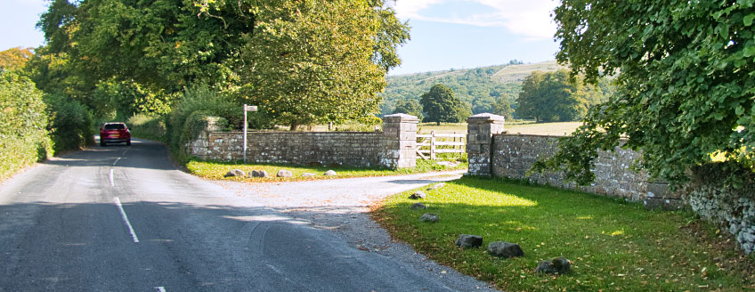
Once you have torn yourself away from the sleepy village setting (or bustling tourist-trap, depending upon the time of year), head down to the church, through the main gate, and round to the far-left rear gate. Turn right down Priest Lane, then left onto Aynsome Road (the main road to High Newton) for about half-a-mile until you see the entrance to the Longlands wedding venue (shown as Hampsfield Hall on the OS map), as shown below.
The road to High Newton is two-way but has no footpath, so you need to walk where you can be seen by oncoming traffic, whilst also being ready to step to the side if a motorist is more interested in the views than in what is on the road ahead. If you would rather not walk on this road then take Greenbank Lane north out of Cartmel, and cut across to Aynsome Mill Farm via the footpath marked on the OS map, and then on to Longlands via a much shorter stretch of road.
Another way to shorten the time spent on this road is to take the footpath eastwards at Borwick's Aynsome Farm, but you are only saving a few hundred yards, and you will miss out seeing the rather colourful (in the summer) walled garden at Longlands.
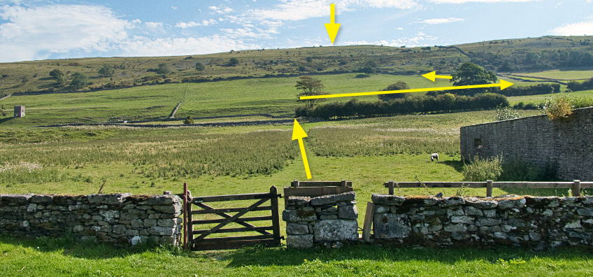
Follow the long driveway to the collection of estate cottages that is Longlands, then right (due east) towards and through the squeeze-stile shown in the photo below. Take a moment to survey the route ahead. The top yellow arrow below shows the approximate location of your target for the climb ahead: Hampsfell Hospice. To get there, head directly ahead to the largest tree in front of you, where you will find a gate into the next field. The footpath follows the perimeter of this field (as shown below), so do not be lazy and walk directly ahead. On the far side of the field (shown by the third arrow up) is a gate that is normally open, which leads on to the steepest part of your climb.
When you are at this point, you will not be able to see your target, so just keep climbing upwards across the patches of scree, perpendicular to the contours of the hill. Try to look and think ahead with the route you take as the small bushes of gorse can be very sharp in the dry weather of a hot summer. Better to take a zig-zag route upwards that avoids the shrubbery.
All being well, by the time you get to the top of the hill, you shouldn't be too far from the hospice.
Hampsfell Hospice was built in 1846 by the vicar of Cartmel as a shelter for travellers. Inside are stone benches and boards of text commemorating its construction and praising the views. Stone steps lead to the roof which offers a 360° panorama view of Morecambe Bay, much of the rest of the Lake District National Park (which you are now standing in), Arnside Knott, the Kent Estuary and the Yorkshire Dales beyond. Hampsfell is the focus of a entire chapter of one of Wainwright's books of walks, so well worth the climb.
Once you've taken in the fabulous views, head south-south-west to Fell End following the paths shown above. Keep to the high ground and you can't go wrong as the vista in front and around you proves that tiny photos on a web page really don't do the South Lakelands vistas much justice.
Fell End is marked by the cairn shown below, although you probably won't see it until you are almost on top of it, as once you are walking in the low areas of land, it is difficult to get the bigger picture of where exactly you are.
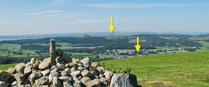
Look west and you will see most of the route you have walked today. The top yellow arrow below marks the first trig-point you climbed to - How Barrow. The lower yellow arrow marks Cartmel, where you had your packet of crisps (or beer/lunch/whatever). And if you look north you'll see Hampsfell (or Hampsfield Fell, to give it its original name), where you have just come from.
Looking east you will see the Kent Estuary and Morecambe Bay, with Arnside and Silverdale beyond, and if you look south-west on a clear day, you'll even see Blackpool Tower some 27 miles away. Morecambe Bay is the largest expanse of intertidal mudflats and sand in the UK, covering a total area of 120 sq miles ...yes, you read that correctly! The bay is rich in cockle beds, and has seven main islands: Walney, Barrow, Sheep, Piel, Chapel, Foulney and Roa. You might have noticed Chapel Island when you looked across at Ulverston from How Barrow. As the name suggests, this island used to be home to a 14th century chapel.
If you hear what sounds like an air-raid siren during your walk today, know that you are not imagining things ...this is a warning to anyone brave or silly enough to walk far onto the sands of Morecambe Bay without a guide, that the tide is coming in. And when you consider that almost the entire bay as you are seeing it now, is devoid of water at low tide, and deep under water at high tide, it doesn't take a genius to work out that the tide comes in quicker than many people might expect. Many have drowned underestimating the speed of the tide and the scale of the bay, which is far wider and more expansive than it might look from the top of Fell End!
Once you are ready to continue, head down the fell in a southerly, then south-easterly direction to the bottom-left corner of the field. Cross the stone-stile onto Spring Bank Road, then follow it down to Grange Fell Road. Turn right and walk downhill past the Grange Fell Golf Club on your right, and Grange Fell Cemetery on your left. At the end of the road turn left and then immediately right down a narrow lane alongside a small caravan park.
Follow this lane south-east, then east as it bends uphill. After a few hundred yards you will see a stone-stile next to a gate on your left, which you should traverse and head south-east around the hillside on your left. As the just-visible path heads towards Allithwaite, keep your eyes peeled for another stone style in the wall below you, for the footpath marked on the OS map has been altered, leaving you trapped in a corner if you follow the map and do not take this earlier exit from the field.
You are now on Wart Barrow Lane, just a short climb away from the centre of Allithwaite where you started your walk earlier in the day.
If you complete this walk, please let me know what you think of it in the comments section below, as it would be nice to know if my efforts are found to be worthwhile.

")